Projects Led by NFI Partners
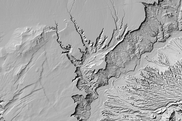
EarthDEM
Surface topography is among the most fundamental Earth Science data sets. EarthDEM is a collaboration to produce very high-resolution digital elevation models (DEM) of the entire Earth.

Geomagnetic Secular Variation Forecast
Geomagnetic data assimilation provides accurate estimates of the core state for fundamental research into questions about the Earth’s interior structure and its evolution, and provides accurate secular variation forecasts for models that are used for industrial and navigational applications. This project investigates the optimal ensemble sizes for assimilations.
Hydrologic Conditioning of TanDEM-X
This project is focused on a dramatic improvement in the TanDEM-X hydrologically conditioned digital elevation map (DEM) which will allow for the best-available datasets to be leveraged for a wide array of hydrologic applications.
Scalable Object Detection
This project will use the robust regression algorithm and Blue Waters to perform object detection among millions or billions of images.
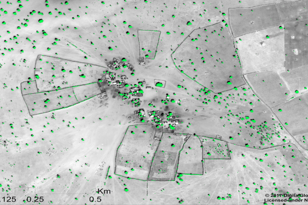
Tree Crown Area, Satellite Imagery, and Deep Learning
Scientists demonstrated a new method for mapping the location and size of trees growing outside of forests, discovering billions of trees in arid and semi-arid regions and laying the groundwork for more accurate global measurement of carbon storage on land.
Projects Led by NFI Staff
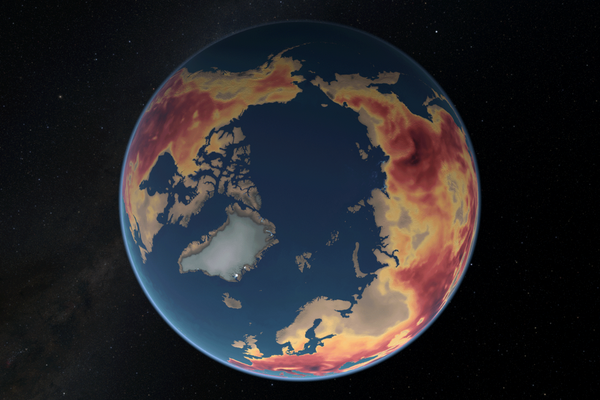
Atlas of a Changing Earth
To help guide and inform possible solutions to changing Earth surface features, scientists turned to satellites and supercomputers. Their work is captured in this documentary, shown in planetariums and other venues.

Education and Workforce Development
The New Frontiers Initiative prepares the current and future workforce to address the computing and data analytics research and development challenges facing our nation’s intelligence community through opportunities to learn new skills and techniques to accelerate their research and development efforts.
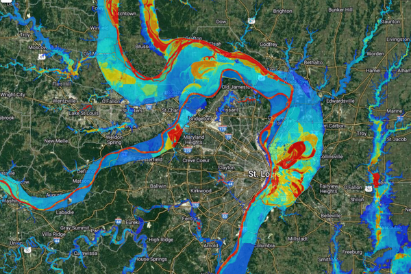
Ironfist
The Flood Inundation Surface Topology (FIST) model combines previously obtained terrain elevation maps (such as from the EarthDEM project) with limited concurrent remote sensing observations, such as zero-depth points, to generate detailed and real-time flood inundation maps.

Labyrinth
Labyrinth aims to rapidly solve Army Defensive Cyber Operations information technology problems by quickly acquiring intellectual property through new and innovative ways of adjusting capabilities, analyzing problem areas, and developing and assessing prototypes. The University of Illinois is one of two academic institutions within the 700-member Consortium for System of Systems Security (SOSSEC) selected to participate in Labyrinth 2.0. The University’s efforts are led by NFI and NCSA staff.